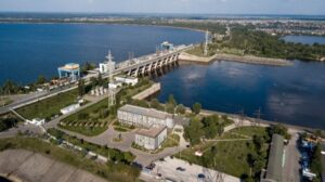
In the very first days of the russian army’s major invasion of Ukraine there was a threat of damage to the Kyiv Hydroelectric Power Plant (HPP) dam. Apocalyptic predictions about a huge wave that could demolish half of Kyiv and about the possible destruction of the Kaniv and Kremenchuk dams of the Dnipro cascade were spread on social media and in some mass media. It was important for Ukrainians to get objective information about the threat and be prepared for all scenarios.
The accurate data were provided!
The results of the work of researchers from the Institute of Mathematical Machines and Systems Problems of the National Academy of Sciences of Ukraine were very helpful. Two months before the war, they completed the project ‘Predicting the Hazardous Effects of Radioactively Contaminated Surface Water and Coastal Flooding: Development of Models and Their Implementation to Reduce the Consequences of Emergency Situations in Kyiv Caused by the Dnipro River Waters’. The project was funded by a grant from the National Research Foundation of Ukraine.
“We assessed two main risks: the threat of radiation contamination of water and the threat of coastal flooding,” explained project PI Roman Bezhenar. “In particular, we developed a model to calculate the flood zones of Kyiv as a result of spring floods or the destruction of the Kyiv HPP dam.
In the model of possible flooding, the researchers used a new technology of parallel calculations on GPUs. To put it simply, the prognostic system allows researchers to quickly assess the risks of flooding every building in the capital and settlements up to the Kaniv HPP dam. This particular mathematical model was useful for assessing possible consequences of the possible destruction of the Kyiv HPP dam as a result of the russian aggression.
“An improved version of the flooding model was developed by the Institute’s employees Maksym Sorokin and Oleksandr Pylypenko,” said Prof. Bezhenar. “Oleksandr volunteered to defend Ukraine in the first days of the war, but Maksym continued his work. He calculated two scenarios of dam flooding for the capital and settlements near the Kyiv Sea.
The researchers published their main findings on the website of the NASU and submitted them to the State Emergency Service of Ukraine. The researchers denied panic predictions of a multi-meter wave and explained that the water would rise gradually in the event of dam damage. The maximum level will be reached in 8 to 20 hours from the moment of destruction, depending on the distance. “This time is enough to warn and evacuate people from the most dangerous areas,” the source emphasized. “By the way, although the areas of potential flooding are significant, people only need to climb to the second floor to avoid danger.
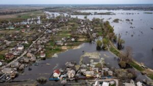
The researchers also created a map of possible flooding and provided access to it to the relevant services (in particular, specialists of the State Emergency Service of Ukraine).
Experts from the Kyiv City State Administration’s Department of Municipal Security and the Prosecutor General’s Office appealed to the research team with a request to provide as much information as possible. “We responded promptly to the requests,” added the PI. “In particular, at the request of the Prosecutor General’s Office we calculated the area of the left bank of the capital that would be flooded in the event of a dam break at the Kyiv HPP.
We asked Roman Bezhenar how, in his opinion, the cooperation between the state and researchers can be strengthened, in particular, in order to ensure the safety of communities?
“In the field we work in, it would be good to develop crisis centers,” he replied. “The employees of the centers should have the highest possible qualifications, work with the most modern software products and help public services make operational decisions regarding the safety of people.
Interviewed by Svitlana Galata